Unlocking the Future of Geospatial Technologies: NECTAR Launches 10-Day Mobile Campus GIS and Remote Sensing Training Program in Shillong, Meghalaya
Shillong, April 8, 2025 — In a groundbreaking initiative to empower students, researchers, and professionals with essential geospatial skills, the Northeast Centre for Technology Application and Reach (NECTAR), in collaboration with Cotton University and St. Anthony’s College, Shillong, has launched the fourth batch of its highly anticipated 10-day Mobile Campus-based GIS and Remote Sensing training program. This dynamic training, aimed at honing practical skills and expertise in GIS, remote sensing, digital image processing, and cartography, commenced today at St. Anthony’s College.
The Geology Department of St. Anthony’s College, in association with NECTAR, has spearheaded this training program, designed to equip participants with hands-on experience and in-depth knowledge in cutting-edge geospatial technologies. This initiative serves as a vital platform for developing the skill set necessary for tackling regional challenges in the Northeast, particularly in the difficult terrains of Meghalaya and other parts of the region.
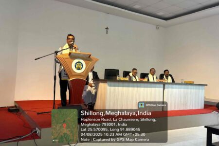
Dr. Arun Kumar Sarma, Director General of NECTAR, inaugurated the training program with an inspiring address to the students. He emphasized the significance of this opportunity for students to dive into the world of geospatial applications through expert-led practical sessions and advanced software tools. Dr. Sarma also highlighted NECTAR’s unwavering commitment to advancing geospatial research in the Northeast, underscoring the role of GIS and remote sensing in addressing regional issues such as environmental management, disaster control, and resource mapping.
Stated “The world is experiencing a rapid evolution in geospatial technology, with GIS and remote sensing transforming not only research and decision-making but also governance. These technologies are crucial for addressing climate challenges, enhancing disaster preparedness, managing resources, and supporting sustainable urban planning,” said Dr. Sarma during his keynote speech. “For regions like Northeast India, with its unique environmental and socio-economic challenges, the adoption of geospatial tools can be a game-changer. This training program plays a crucial role in fostering a data-driven approach to solving the region’s issues.”
Dr. Sarma also encouraged students and faculty to engage with NECTAR’s geospatial infrastructure and contribute their innovative ideas to furthering research in this vital sector. He assured participants that NECTAR remains committed to expanding geospatial research programs, bridging the gap between theoretical knowledge and practical application in the region.
The event is graced by the Principal of the College Fr. Arcadius Puwein by his warm welcome address, urging students to explore the expertise facilities of NECTAR and Shri Rajendra Jena, Chief Geomatics Officer highlighted the objective of this unique off campus program of NECTAR with meticulously designed to the comfort of students and curriculum in synchronized more towards the practical applications. Dr Colin Z Renthlei, Advisor (Technical), NECTAR also joined the event and discussed about the future collaboration on faculty development programs for better learning ecosystem in the sector of Geospatial Technology Application through the initiatives of St. Anthony’s college.
On the sidelines of the program the Director of the Centre for Clouds and Climate Change Research, Cotton University, Dr. Rahul Mahanta who coordinates and oversee the whole program in the region, shares an inspiring message to Honourable dignitaries, esteemed faculty members, students and extended his heartfelt gratitude to the St. Anthony’s College for bringing together experts and enthusiastic students in this important domain. He emphasized the comprehensive nature of the training module and its potential to empower future professionals in geospatial sciences. He remarked through his note-
“In the context of Meghalaya, these technologies are particularly relevant due to the state’s vulnerability to climate change impacts, such as landslides, flash floods, and erratic rainfall patterns. They also play a vital role in mapping and monitoring the forest cover, which is crucial for biodiversity conservation. With the rise of smart cities, the integration of GIS technologies in urban planning will be pivotal in creating sustainable infrastructure and managing resources efficiently. The potential of GIS and Remote Sensing technologies can only be fully realized when we build a skilled workforce. Meghalaya has a strong intellectual base, with institutions like St. Anthony’s College providing the right platform for academic excellence. By offering programs like this training, we are not only equipping individuals with the technical skills but also nurturing future leaders in the field of spatial science who will make a meaningful impact in their communities and beyond.
The training, which spans ten days, offers a comprehensive curriculum blending theoretical insights with hands-on practical sessions. It covers a wide array of topics, ensuring participants gain the necessary skills for utilizing geospatial technologies in real-world scenarios. The training is being conducted through industry level experienced resource persons of NECTAR Shri Sattyam, Junior Geomatics Officer, Smt. Roshini Rai, Project Associate and Kumari Nikita Gogoi, Project Assistant, well supported and facilitated by Head of the Geology Department, Dr. Van Jennifer Joan Wallang, Associate Professor and Faculty member Mr Dibinus Ksiar of St. Anthony’s College. Upon completion, participants will undergo assessments, and successful candidates will receive certification, marking their proficiency in GIS and remote sensing.
In line with India’s goals of digital transformation, climate resilience, and sustainable urban development, this program aligns with national objectives and supports skill development in geospatial technology. The future roadmap for this initiative includes the introduction of advanced GIS courses, drone-based geospatial data acquisition workshops, and collaborative research initiatives with national and international institutions.
By offering high-quality skill-building opportunities, this training program is poised to be a key stepping stone in shaping the future of geospatial research and application, with far-reaching benefits for the region and beyond.
Cotton University, NECTAR and St. Anthony’s College Collaborate to conduct Geospatial Learning in Shillong-10-Day Training Module on GIS and Remote Sensing Inaugurated at St. Anthony’s college
